Computer vision
Satellite land use and change
Land use from all 13 Sentinel-2 bands with a band-ablation study, and building change detection with a Siamese U-Net.
The problem
Sentinel-2 records 13 spectral bands, but most vision models only see RGB. I wanted to know how much the other bands add once a CNN already has spatial context, and whether they help more when labels are scarce. The second half asks a related question for change detection: can raw pixel differences find new buildings, or does it take a learned model?
What I built
- Rebuilt the first layer of an ImageNet ResNet-18 for any number of bands: the RGB bands keep their filters and every other band starts from their mean.
- Ran a band ablation on one fixed split of 27,000 EuroSAT patches: 9 band sets, a random forest that sees only per-band statistics, and 1 %/10 %/100 % label budgets.
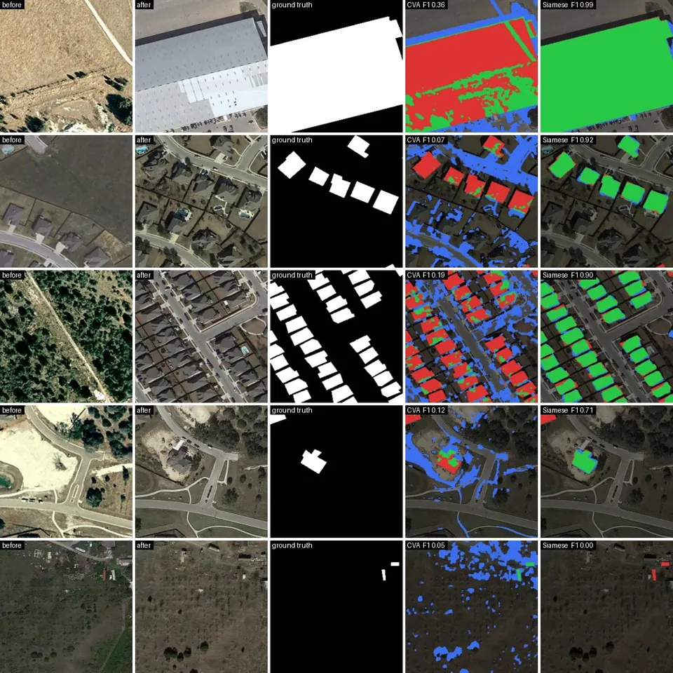
- Trained a Siamese U-Net with a shared ResNet-18 encoder on LEVIR-CD. The decoder gets the absolute feature difference of the two dates, so unchanged content cancels.
- Compared it with Change Vector Analysis, once with Otsu per tile and once with a threshold tuned on validation, and exported both models to ONNX and CoreML.
Results
| Model | Bands | Test accuracy | Macro F1 |
|---|---|---|---|
| Random forest | RGB | 0.797 | 0.789 |
| Random forest | all 13 | 0.910 | 0.905 |
| ResNet-18 | RGB | 0.983 | 0.982 |
| ResNet-18 | 10 non-visible bands only | 0.983 | 0.982 |
| ResNet-18 | all 13 | 0.987 | 0.987 |
What the results show
- Spectra and spatial context largely stand in for each other. Without spatial features the extra bands are worth 11 points; with a CNN they add 0.4 points (91 vs. 68 errors, McNemar p = 0.02), mostly in vegetation classes.
- I expected extra bands to help more with few labels, and they didn't: RGB and all 13 both score 0.896 with 1 % of the labels.
- For change detection the learned model reaches F1 0.890, while CVA stays at 0.117 even with a tuned threshold. Pixel differences can't tell buildings from seasons, shadows or new roads.
- Quantising raw 13-band input with one 8-bit scale zeroes the cirrus band and drops accuracy to 0.866, so the input scaling stays in float.
Limitations
- EuroSAT's random split lets neighbouring patches of one field land in train and test, which flatters every model. A geographic split would measure the leak.
- One seed per configuration, and validation accuracy was still rising at epoch 8.
- The LEVIR-CD mirror stores JPEGs, so the change results aren't a like-for-like comparison with papers.
Full results, commands and figures are in the repository README.